Gamkaskloof and back.
21 April 2025
The warm darkness enveloped me. I was slightly ahead of my 04:00 target, but the old Cruiser started eagerly. A thermos of coffee and some rusks to hand we eased through the suburbs and on to a practically deserted motorway. It was so quiet at the Johannesburg interchange that I thought for a good five minuted that I had taken the wrong direction.


Grassmere Toll Plaza was a first stop. Now a few trucks joined me on the way south. Slowly the eastern horizon paled and then became yellow, orange, pink. The sunrise over the Northern Free State was a sight to behold, and it was full daylight when I stopped at Kroonstad to fill the Cruiser and have some snacks myself.
The next fuel stop at Bloemfontein broke into an almost meditative trance, and I hastened to rejoin the now rather busy traffic. At Colesberg I stopped again for fuel and a nice chicken and mushroom pie. Now we crossed into the Northern Cape, and soon encountered road repair teams. At the same time my partner called with a translation question. Unable to concentrate I pulled over near Richmond to parse out a sentence construction. Then back into the traffic. At several long stops where roadworks necessitated one way traffic I met up with fellow migrating people, among them a long distance truck driver who gave fascinating information about his industry, his work schedule and his hopes for the future.
Then the traffic began to flow again and I went on to Three Sisters for fuel. From here it was only a short hop to Beaufort West where I could spent a delightful weekend with children and grandchildren.
24 April 2025
Monday morning invited me on to Prince Albert firstly along desert roads, then a climbing, swooping ride through valleys and vineyards. A harsh land with some verdant oases. In Prince Albert I encountered, again, the amazing personality of the people. A softness born out of their harsh environment?
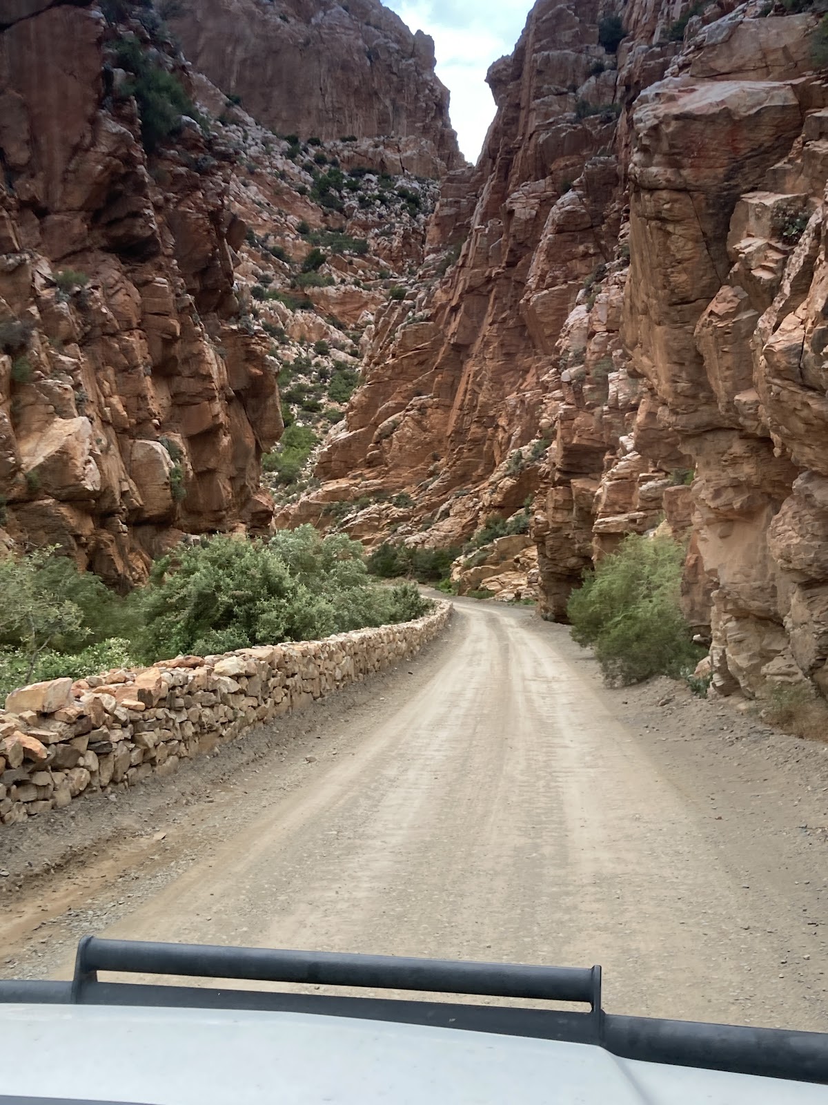
Refuelled, we turned back towards the mountains. The Swartberg Pass remains one of the most fantastic feats of engineering. The road worms its way through crags and cliffs of tortured, convoluted rock where klipspringers perch to watch you go by.


Driving becomes a symphony of concentration on the road surface, the technical management of the vehicle, the ever changing scenery and the magnificent vistas that open at every turn. For a while I played my usual photography game, looking at a particularly interesting rock formation in the distance, and ever looking for a better angle, until the formation disappears from view before I had even taken my photo.

The descent onto the basin of Gamkaskloof is a voyage in itself, with the long winding load slowly disappearing under the wheels. A couple of Klipspringers dashed across the road in front of me, stood looking in the distance, then gave me a disapproving look and vanished into the vegetation.
A big bird of prey turned on an updraft for a while, too far to be photographed or identified. And then the valley opened, welcoming me home.


walks up into one of the kloofs tantalised me with promises of mysteries just around the next corner, no, the next.

The spekboom was in flower and enticed me to take yet another photo, cool brooks tempted with dragonflies like flying jewels. Crab skeletons testified to the presence of otters. Tadpoles promised mosquitos. A rock ledge overhanging a likely path for antelope smelled like cat and I could imagine a leopard settling here to wait for dinner.
All too soon the time ran out, and the weather changed. I left in soft rain, feeling that the valley wanted me to stay. With the different weather the views

were also completely different, and the beginning of winter weather was clearly visible.

Having read some of the story of the road builders I could appreciate my trip back to the turn on to the Swartberg Pass even more. Going down the pass I had to wait for vehicles coming up, the roadway is narrow and treacherous in places. Then I refuelled in Prince Albert and headed for Beaufort West. But first I stopped at the SilverKaroo road stall to pick up some home made delicacies.


29 April 2025
We made a side trip with the children through Meiringspoort to George. This road has much more traffic, but gave similar views of the geology. One can only imagine the challenge to the nomad farmers who wondered if there was a way to get to the great inland plains. From the coastal plain the mountains look impassible, and one can only wonder at the perseverance and ingenuity of those that made it through here.
31 April 2025
On Monday morning the road welcomed me and I stopped at Three Sisters to fill up. Once again the fuel guy gave me his opinion of the weather and local politics, then I discovered the mild empty plains to Graaff Reinet. As a precaution I filled again, and the attendant went out of his way to explain how to get out of the maze of one way streets and road works. Some daunting hills and twisty roads led me to the sudden greenness of the Nieu Bethesda valley, where to young men riding bareback on horses welcomed me. A slight confusion about my accommodation developed well, and I hurried to take in the Bushman Heritage Museum. https://bushmanheritagemuseum.org/

The well-known Owl House was an unsettling experience. The work of Helen Martins, an eccentric person who devoted her life to making sculptures, not only of owls, left me with a feeling of not having understood anything. A young German tourist summed it up: “Very weird.”
1 May 2025
A good night’s rest and pre-prepared breakfast at 04:30 allowed me to be on the road before sunrise. My haste to make inroads in the nearly 900 kilometers and the unknown road had the Cruiser drifting around a few bends before I settled down. Sunrise was dreary in the threatening rain, but the fuel stop at Colesberg provided another chicken and mushroom pie.

Traffic was heavy, with loaded trucks competing in overtake games. At one point I overtook three at a time, and the fourth made space for me. So did an oncoming truck, and we had a Cruiser sandwich for a second or two. That was when I remembered the limerick of the novice near Porlock. I drove slower.
Bloemfontein, Kroonstad and the Vaal river went by with some rain at times. I managed to catch the tail end of the rush hour in Johannesburg and did about ten kilometers in first gear. But I made it home before dark, to the joy of the dogs. The new puppy, Mila, took a minute to remember, then she went zoomies around the garden.


